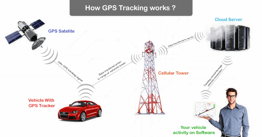
In this blog post you will understand how GPS tracking software works. Let’s start with:
What is GPS Tracking?
GPS tracking is the surveillance of location through the use of the GPS (Global Positioning System) to track the location of an object like a Bus, Train, or Car remotely. The technology pinpoint longitude, latitude, ground speed, and course direction of the target.
The Global Positioning System consists of approximately 30 well-spaced satellites orbiting Earth. Ground receivers enable people and companies to pinpoint their geographic location using this system.
GPS tracking is precious for IT companies, Police, Firefighters, Military, and large carrier businesses. many companies use Automatic Vehicle Locator systems. AVL systems include tracks of vehicles, each equipped with a mobile radio receiver.
How GPS Tracking Software Works?
GPS is a worldwide radio-navigation system formed from the constellation of 24 satellites and their ground stations. The Global Positioning System is essentially financed and managed by the U.S Department of Defense.
There are many companies in the market that provide GPS Tracking Software.
Uffizio provides a user-friendly and advanced GPS tracking platform. Uffizio – GPS Tracking Software is aimed to provide all the essential services in a single application. It is compatible with any GPS tracker and runs on every platform without any issues. It has multiple functionalities that make the applications simple to use. Uffizio has multiple vehicle tracking software for your distinct requirements. The main goal is to facilitate their customers with ideal solutions.
How does GPS Tracking Software work?
There is 24 satellite including GPS in the space, they always spin around the earth 365 days a year and 24 hours a day and they complete one round in 12 hours.GPS (Global Positioning System) is a type of GNSS ( Global Navigation Satellite System). It Provides tiny electronic receivers to define the latitude, longitude, and altitude of a point.
Whenever your device gets a signal from one satellite (for example Red) then you should be somewhere at the red sphere which the center is the satellite and the radius is the distance between your device and the satellite.
When your device gets a signal from the second satellite (let’s assume yellow)then you should be on the Red sphere and also on the yellow sphere means you are on the intersecting circle of two spheres. Now you are in the circle.
Now when your device gets a signal from the third satellite(blue) then you get the exact position of your device, the intersecting point of the three spheres.
This is how the user is using GPS Tracking Software in Device.
GPS manages a network of satellites that are orbiting the Earth. The time you turn your GPS tracker, the receiver receives the signal from these satellites about their current time and location. The receiver then estimates its distance from the satellite based on the event taken by the signal to reach you.
DISTANCE=TIME*SPEED
Why use GPS Tracking?
- Reduce Paperwork
- Tracking Stolen vehicle
- Locating Kids
- Tracking Criminals
- Tracking rental cars and Buses
- Better Customer Service
- Optimize financial management
- Prevent Unauthorized Vehicle Use


