LBS – Location Based Service
A Location-Based Service (LBS) refers to a technology that utilizes the geographical position of a user or device to provide relevant information, content, or functionality. LBS relies on the ability to determine the location of a device through various technologies such as GPS (Global Positioning System), Wi-Fi, cellular networks, or sensors.
GPS tracking system or Fleet management system simply means tracking vehicles of your fleet with accuracy and consistency. However, this accuracy and consistency can be difficult to achieve sometimes. Let us go through one simple example to understand it better.
Suppose you have an important consignment to deliver to a destination. A route to the destination consists of tunnels, mountain areas, and remote locations. You can not rely on GPS all the time in this type of terrain.
GPS signals might get lost because of various reasons like dense areas, underground routes, tunnels, and GPS malfunction. In addition to this, in this type of condition, the chances of accidents and vehicle theft increase.
In such a situation, losing the GPS signal makes it extremely difficult for a fleet manager to track and monitor the fleet. And your tracking system won’t be able to help you out when you most need it.
How to overcome this situation?
Don’t worry. Solving your problems before they even arise is our primary job. And the solution to this problem is “Location-Based Service” which is commonly known as LBS.
What is Location Based Service?
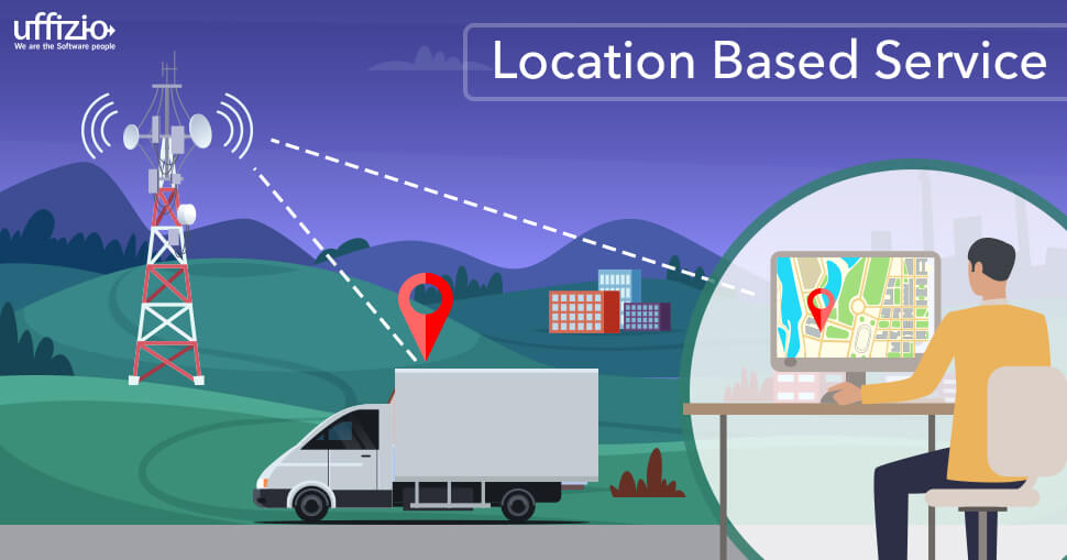
LBS stands for location-based service. It is designed for tracking your vehicle with the help of cellular towers. So, a vehicle is located by the coordinates of the closest GSM base station. LBS is not as accurate as GPS, but it’s very helpful when GPS positioning data is unavailable.
LBS makes use of embedded satellite navigation receivers or network-based technologies such as cell identification or triangulation from the location of the base station transmission cells to determine the position.
How does it work?
To track vehicles, we use a GPS Tracking system. Which receives coordinates from the satellite and uses its latitude & longitude to provide you with the exact location of the object. Continuous high-speed internet is necessary for obtaining an accurate location. And if your vehicle moves in a region where there is no internet, then it becomes impossible to track your vehicle.
In this case, the LBS tracker sends data to the software with additional parameters mentioned below. These parameters help the software in identifying the location of the closest cellular tower to the device. Therefore to locate a vehicle by LBS, the device should send at least 4 parameters: MCC, MNC, LAC & Cell ID.
MCC (Mobile Country Code)
It identifies the country code for example: India – 404, USA – 310, Hungary – 216 so on.
MNC (Mobile Network code)
It is a unique code that identifies a mobile network operator. For example MNC – 02 -Vodafone India (Delhi Operator), MNC – 10 – Airtel India (Delhi Operator) so on.
LAC (Location Area Code)
Each location area consists of a set of base stations that are grouped together to optimize signaling. Each location has its own unique number. For example LAC – 011 -Delhi, LAC – 212 – New York.
Cell ID
It is a unique number used to identify each base transceiver station (BTS) or sector of a BTS within a location area code. A valid CID ranges from 0 to 65535 on GSM and CDMA networks and from 0 to 268,435,455 on UMTS and LTE networks.
The LBS device used in your vehicle consists of a GSM sim card so whenever your software doesn’t receive a GPS signal from the satellite network, the LBS device makes use of the above-mentioned parameters and collects data from the multiple Cellular towers. It then checks in which country, region, and area your vehicle is moving with the help of those parameters. And provides you with the location of your vehicle.
How does Trakzee work with Location Based Service?
Trakzee – an advanced fleet management software, works with most of the advanced trackers including LBS trackers.
You just need to configure the LBS tracker like any other GPS trackers on the platform with a single screen and it’s all set. You don’t need to perform any other operation. Trakzee will take care of everything else.
Trakzee maintains a database that contains information about all the MCC, MNC, CID, and LAC codes. So, whenever any device sends those codes, our database quickly identifies the exact location of the device. And you will get the results in a fraction of a second.
We hope you got the idea of how LBS works and why this is so important. If you want to know more about it then please contact us.


